Race Course Descriptions
NO PRE-RACE RUNNING or MTB riding
OF ANY PART OF OUR RACE COURSE!
Our generous landowners grant permission to use their land FOR RACE DAY ONLY
Using these TRAILS outside of race day jeopardizes the future of our race.
GONE OFF COURSE…
If you get lost (but you won’t)
you must go back ON YOUR OWN
to the spot you went off course WITHOUT assistance
(NO car rides etc) and then continue.

50 Mile Course Description (subject to change)
The Vermont 50 goes through many private properties, which makes the race special. It can also causes last minute changes to our race course. We will do our best to keep these changes to a minimum. Any last minute course changes will be revealed at the mandatory pre-race meeting, please be there to hear these changes!
FYI-The majority of the trails on our race course are quite rideable/runnable with little in the way of rocks or roots. Almost all are part of the Green Mountain Horse Association trail network and are well maintained.
While on course stay to the right, single file and obey all traffic laws. Public roads will be open during the event, motor vehicles not associated with the race may be encountered, DO NOT assume right-of-way unless directed by race officials. Many of the dirt roads are narrow and cars should be given as much room to pass as possible.
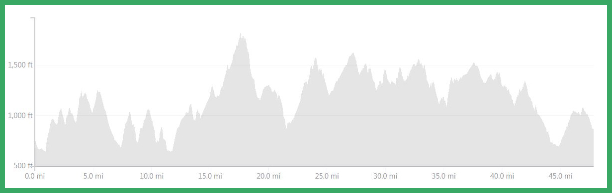
The Course starts on Ski Tow Road about 100 yards from the BIG Tent. You head down the paved Ski Tow Rd. to Rte. 44. Sharp left, followed by an equally-sharp right turn onto unpaved Brook Rd. After 4/10 mi. turn left to start a 2.3 mile stretch of climbing and rolling gravel roads to the first aid station.
Travel 2 miles of uphill on snowmobile ATV trail. Then 1.5 miles of road before your next aid station, followed by 4 more miles of trail to Skunk Hollow.
After the aid station at the Skunk Hollow Tavern (@12 mi.), the next 8 mile stretch includes less than 2 on trail. Our race course alternates between road and trail and gives you plenty of hills to deal with.
At mile 20 you’ll encounter 1812′ Garvin Hill, the highest point in Hartland, and wind up over and around it before heading back south on more trails and gravel roads. This includes a long descent of Densmore Hill Road, part of Vermont 100 Endurance Race course, and then back up an equally long hill trail. At about 28 miles you come out onto Reeves Rd., where the 50K joins the 50M course. Travel 2 miles of fairly decent dirt road, passing Smoke Rise Farm.
After Greenall’s Aid Station at 31.9 mi there is a weaving route through the woods and meadows around Blood Hill, some steeps near the Vermont 100 Finish area meadow and a climb over a sizable hill. The last 11 miles you’ll be seeing alternating road and trail.
After the Johnson’s Aid Station you enter Ascutney Trails Association trails, a year-round system of non-motorized recreational trails that is highly regarded as one of Vermont’s premier mountain bike networks.
With one mile to go you’ll start crisscrossing Mt. Ascutney’s lower Alpine ski slopes on mostly grassy terrain, until you can look down at the finish line before negotiating the last few switchbacks.
Course Percentage Breakdown:
Total vertical is about 8,900’
Trails or jeep (unimproved) roads 67%
Gravel roads 30%
Pavement 3%
FYI-Those familiar with the Vermont 100 course, the 50 Mile is basically superimposed on the last third but actually shares less than 10 miles of it.

50 Km Course Description (subject to change)
If you are looking for something that isn’t quite so challenging as the 50 mile, this is the race for you.
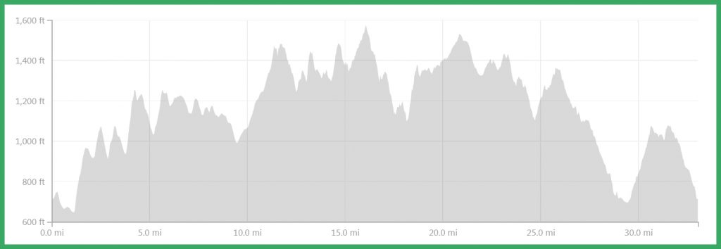
The Course starts on Ski Tow Road about 100 yards from the BIG Tent. You head down the paved Ski Tow Rd. to Rte. 44. Sharp left, followed by an equally-sharp right turn onto unpaved Brook Rd. After 4/10 mi. turn left to start a 2.3 mile stretch of climbing and rolling gravel roads to the first aid station.
Next you’ll run 2+ miles of fairly steep snowmobile-ATV trail then exit the trail onto gravel road, at about mile 6, you take a sharp left.
(50 milers turn right on their course)
Your second aid station (2K-Ralph’s) followed by 3+ miles of gradual uphill smooth road. You may see 50 milers joining in from a trail on your right.
50K/50M Split They’ll be with you for ¾ mile until you get to the Margaritaville Aid Station at Smoke Rise Farm, where you turn left onto trail again, and 50 milers keep going straight. After another ¾ mile you’ll join the 50 milers again, from which point your course to the finish is the same as theirs.
After the Greenall’s Aid Station at 13.4 mile there’s another road segment, followed by a weaving route through the woods and meadow around Blood Hill.
You are on the 50 Mile course to the finish line and can read the description above.
Course Percentage Breakdown:
Total vertical for the 50 Km is about 5,600’.
Gravel Rd. 37%,
Trail or Jeep Rd 58%
Pavement 5%
The courses are marked with 5” bold arrows on white backgrounds.
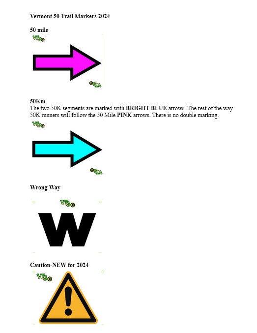
50 Mile (Bike and Run) has PINK ARROWS.
The two 50K segments are marked with BRIGHT BLUE arrows. The rest of the way 50K runners will follow the 50 Mile PINK arrows. There is no double marking.
A large black W on WHITE background means Wrong Way, go back.
A large black TRIANGLE with ! on and orange/yellow background means HAZARD such as a hole, ditch, drop-off, obstruction, etc. i.e. a hazard.
Please view/download this document VT 50 Race Trail Markers