Race Course Descriptions

50 Mile Course Description (subject to change)
The Vermont 50 goes through many Private Lands, which makes the race special. It also causes last minute issues… lands sold, new owners, logging, and so on. There have been a few last minute snarls which could cause some minor changes with distances between stations. This is more of an issue for Runners than bikers. We will do our best to keep these changes to a minimum.
Unlike most running events that traverse public roads, stay to the right, single file and obey all traffic laws. Public roads will be open during the event and participants will encounter motor vehicles not associated with the race. DO NOT assume right-of-way unless directed by race officials. Many of the dirt roads are narrow and cars should be given as much room to pass as possible.
You’ll find out some of these changes at the mandatory pre-race meeting, please be there to hear these changes!
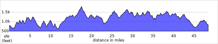
The Course starts on the road only 100 yards from the Registration Tent. You head down the paved Resort entrance road to Rte. 44. Sharp left, followed by an equally-sharp right turn onto unpaved Brook Rd. Now after 4/10 mi. turn left to start a 2.3 mile stretch of climbing and rolling gravel roads to the first aid station.
Now you’ve got about 2 miles of uphill on snowmobile ATV trail. Then 1.5 of road before your next aid station, followed by 4 more miles of trail to Skunk Hollow.
After the aid station at the Skunk Hollow Tavern (@12 mi.), the next 8 mile stretch includes less than 2 on trail. Enjoy it because it’s going to change. A key feature of this course is the fact that it pretty much alternates between road and trail and gives you plenty of hills to deal with.
At mile 20 you’ll encounter 1812′ Garvin Hill, the highest point in Hartland, and wind up over and around it before heading back south on more trails and gravel roads. This includes a long descent of Densmore Hill Road, part of the revised Vermont 100 Endurance Race course, and then back up an equally long hill trail. At about 28 miles you come out onto Reeves Rd., where the 50K route hooks back in. Now there’s over 2 miles of fairly decent dirt road, passing Smoke Rise Farm, but of course, followed by more canopied trail. Be aware that the great majority of the trails on the course are quite rideable/runnable with little in the way of rocks or roots. Almost all are part of the Green Mountain Horse Association trail network and are well maintained.
After Greenall’s Aid Station at 31.9 mi there is a weaving route through the woods and meadows around Blood Hill, some steeps near the Vermont 100 finish meadow and a climb over a 1,600′ attention-getter. In the last 11 miles you’ll be seeing alternating road and trail.
After the Johnson’s aid station you enter the Ascutney Trails network, a year-round system of non-motorized recreational trails that is highly regarded as one of Vermont’s premier mountain bike networks. With one mile to go you start criss-crossing Mt. Ascutney’s lower Alpine ski slopes on mostly grassy terrain, before the dramatic descent to the finish line.
It’s worth all the effort you’ve expended when you can finally look down at the finish line by the base lodge and pound your way down a quarter mile of blessed downhill!
For those familiar with the Vermont 100 course, the 50 Mile is basically superimposed on the last third but actually shares less than 10 miles of it. About 2/3 (67%) of the 50 Mile course is on trails or jeep (unimproved) roads. 30% is on smooth, rolling gravel roads and 3% is on pavement. It is a challenging course, with good footing/traction, plenty of hills and classic Vermont scenery that will knock your socks off. The total vertical is about 8,900’
Note, the following are the approximate percentages:
Gravel Rd./Trail or Jeep Rd./Pavement 50 Mile: 30% , 67% , 3%

50 Km Course Description (subject to change)
If you’re looking for flat and fast, this isn’t for you. If you are looking for something that isn’t quite so challenging as the 50 mile, listen.
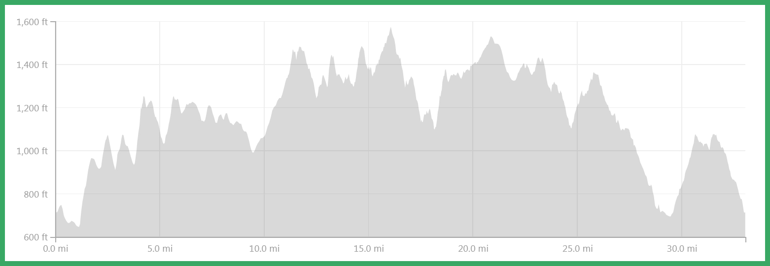
The Course starts on the road only 100 yards from the Registration Tent. You head down the paved Resort entrance road to Rte. 44. Sharp left, followed by an equally-sharp right turn onto unpaved Brook Rd. Now after 4/10 mi. turn left to start a 2.3 mile stretch of climbing and rolling dirt, then gravel roads to the first aid station.
Now it’s time to really get to work, when you enter onto 2+ miles of snowmobile-ATV trail which is fairly steep at the outset. When you exit the trail onto gravel road, at about mile 6, you take a sharp left, whereas the 50 milers went right to tackle 19 miles of stuff you don’t have to worry about.
You’ll get to your second aid station (2K-Ralph’s) shortly, followed by 3+ miles of gradual uphill smooth road. You may see 50 milers joining in from a trail on your right. They’ll be with you for ¾ mile until you get to the Margaritaville aid station, where you turn left onto trail again, and they keep going straight. After another ¾ mile you’ll join the 50 milers again, from which point your course to the finish is the same as theirs.
After the Greenall’s aid station at 13.4 mile there’s another brief road segment, followed by a weaving route through the woods and meadow around Blood Hill. A few more steeps near the 100 mi. Meadow, and a climb over a 1,600’ attention-getter. In the last 11 miles you’ll be seeing alternating road and trail.
From Stones aid station the rest of the way is mostly trail. The trails get progressively tougher when you enter onto the Ascutney Trails network, a year-round system of non-motorized recreational trails, after the last aid station (Johnson’s). From here you have about 2.5 miles to go. In the last mile you’ll be crossing the lower Ascutney Alpine slopes on mostly grassy trail, with some side pitch, mostly to the left.
Almost 2/3 of your total course is trail, most of which provides fairly decent footing, with little in the way of rocks or roots. Eight miles of it is on segments of the 100 Mile course.
The total vertical for the 50 Km is about 5,600’.
Gravel Rd./Trail or Jeep Rd./Pavement 50 Km.: 37%, 58%, 5%
NO PRE-RACE RUNNING OF ANY PART OF THE COURSE!
Use this course only for this race. The property owners do not want it used at other times.
If you get lost (but you won’t) you must go back on your own to the spot you went off course without assistance (e.g. car rides, etc) and then continue.